It’s strange how people read history notes and
take them for granted - let alone being the correct facts! In his History
of Froyle, Tom Knight stated:-
“Until 1860, the way into the village from
the main road was through Gate Lane, or Gid Lane as it is often called.The
Hen & Chicken was reached by a footpath through a wood. In 1860,
Sir Thomas had this wood cut down and the road made from the pond to
the Hen & Chicken. He then had what is now known as the park gates
erected, and a double lodge built there, intending to use Gate Lane
as a private drive. The authorities at the time would not allow him
to close the lane, so the iron gate was never hung. It lay in Blundens
farmyard for many years. This gate weighed 7cwts., and was collected
under the iron salvage drive of 1942.”
This, and much other information, came from
a couple of villagers he spoke with in the 1920s:-
“The writer had conversations with these
two in 1922 to 1925, and they gave clear accounts of what Upper Froyle
was like, about 1860, and before, from what they could remember, and
what their parents had told them.”
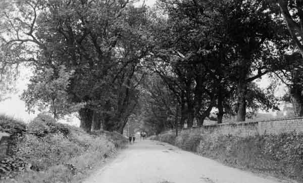
A few years ago the Archive was asked for information
on the Hen & Chicken Hill and especially the wall that separates the
road from the Grounds of Froyle Place (photo above taken in 1912).
The standard ‘origin’ for the wall was its construction by French prisoners
of war during the Napoleonic conflict with France. This would date the
wall to around 1810 - 1815 (ish). Looking at the quote above, why
would anyone build a wall there if there was not a road already there?
Further examination of the Tithe Map (surveyed 1845), clearly shows
the Hen & Chicken Hill! |